Even if the average vehicle fuel economy were 45 miles per gallon—double what it currently is—predicted 2030 carbon emissions from cars would still be 24 percent higher than they were in 1990. Fewer people need to drive to achieve global climate goals, but Americans rely heavily on cars for commuting, groceries, and other outings. If there were a way to aggregate information on people’s driving habits, urban planners could use these data to increase public transit accessibility and decrease our reliance on cars. Kalyanaraman Shankari, a former graduate student in the Department of Electrical Engineering and Computer Sciences at UC Berkeley has done just that by creating a platform for mobile applications to collect individual transportation data through the E-Mission project.
Shankari, along with fellow Berkeley scientists Mogeng Yin, Shanthi Shanmugam, David Culler, and Randy Katz, developed E-Mission, a platform which helps mobile apps easily compute a user’s transportation-related carbon footprint. Apps that use E-Mission can build a quantitative understanding of individuals’ carbon consumption and allow governments to use that information to motivate urban planning developments, such as adding new bus lanes.
E-Mission is not the first platform to compute carbon footprints, but it is the first to do so by collecting user data without requiring manual input, thus making it a more consistent source of information. E-Mission uses a phone’s GPS tracker to record the distance a user travels and then applies machine learning algorithms to determine the mode of transportation. While a simple algorithm determines the type of transport being used by calculating the speed of the device, GPS data could allow E-Mission to make more accurate estimates by combining information from many users. For example, if several app users left from the same location at the same time, that location is probably a bus stop or train station. In the future, by integrating GPS data with pooled user data, E-Mission could predict whether a user takes the bus, train, or some other mode of transportation.
Another benefit of the E-Mission platform is it lets others build emissions computing applications tailored to their userbase on top of the existing software. If, for example, a city government wanted to write a mobile app to track local travel patterns, they can leverage E-Mission software to develop it more effectively than having to write from scratch. Meanwhile, they still have the freedom to customize the app to their specific needs. “If you’re [in] Eureka, you don’t have the same [urban planning] problems San Francisco does, but you still want to fight your sustainability problems,” Shankari says.
Shankari discusses how E-Mission can support agile urban planning, meaning communities can quickly experiment and get feedback with different changes they make. Right now, if a local government changes their infrastructure in some way, they have a hard time knowing if the change was effective in limiting pollution. Because E-Mission collects frequent and fine-grained travel data, governments can quickly figure out whether a change is beneficial or if it needs modification. “We could actually try things where we say let’s go out and put temporary concrete fence posts at 50 places [to create protected bike lines] and see which ones are most useful. Maybe we keep some, and maybe we take some out,” explains Shankari. She also cites repurposing highway lanes to dedicated bus lanes as something communities can experiment with given real-world travel data from E-Mission. By experimentally producing improvements in the city infrastructure and public transportation, governments help residents choose more carbon-efficient modes of transport.
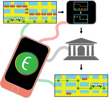 Urban planners can quickly figure out whether their changes reduced carbon emissions with E-Mission software. Image Design: Amanda Bischoff
In the future, Shankari—now a Director’s Fellow at the National Renewable Energy Laboratory—and the team hope to enhance E-Mission on several fronts. One planned improvement is to suggest actionable steps for users to reduce their individual carbon emissions. Shankari and the team are also looking into privacy enhancements to E-Mission. Right now, the government has access to the travel data of E-Mission users, which it uses to provide feedback to local urban planners. Shankari hopes to compile user data such that the government only sees aggregate travel patterns that are pooled across users. E-Mission, however, is already a huge step forward in efficiency and accuracy for computing carbon emissions. If communities can make climate-friendly transportation more accessible, then more and more people will use that climate-friendly transport. And once enough people make even small changes to their carbon footprint, we will see major improvements on our planet’s climate health.
Correction: An earlier version of this article misstated that E-Mission is currently combining information from multiple users and that E-Mission is the first carbon footprint app that does not require manual input.
This article is part of the Spring 2020 issue.